

PeakVisor - 3D Maps & Peaks ID
Discover the Peaks with PeakVisor
Imagine standing on a mountain top, surrounded by breathtaking views, and wondering about the names of all those majestic peaks around you. Well, wonder no more! With PeakVisor - 3D Maps & Peaks ID, identifying peaks is not only possible but incredibly easy and fun. This app transforms your hiking and mountain adventures into something much more insightful, turning every hike into a learning experience.
Features That Elevate Your Hiking Experience
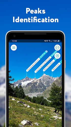
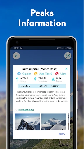
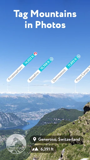
PeakVisor is packed with features that cater to both amateur hikers and seasoned mountaineers. Its primary function is to identify mountain peaks using your phone's camera, and it does this with impressive accuracy. Simply point your device towards the horizon and watch as the app overlays names and elevations of visible peaks right onto your screen. It's like having a mountain guide right in your pocket!
One of the standout features of PeakVisor is its 3D maps. These aren't your typical flat maps; they're detailed, interactive, and give you a much better understanding of the terrain. You can zoom in and out, rotate, and even tilt the map to get the best view of your hiking area. This feature is particularly useful for planning your route and understanding the topography of the region.
Seamless Navigation and Offline Access
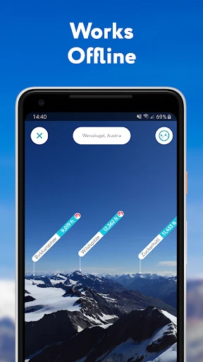
If you're worried about losing signal in remote areas, PeakVisor has you covered. The app allows you to download maps for offline use, ensuring you won't get lost even in the most secluded locations. This feature is a game-changer for those who enjoy venturing off the beaten path.
Moreover, the app's navigation capabilities are top-notch. It provides detailed hiking routes and tracks your progress in real-time. You can save your favorite trails and share them with friends, making it easier than ever to explore new terrains together.
Why PeakVisor Stands Out
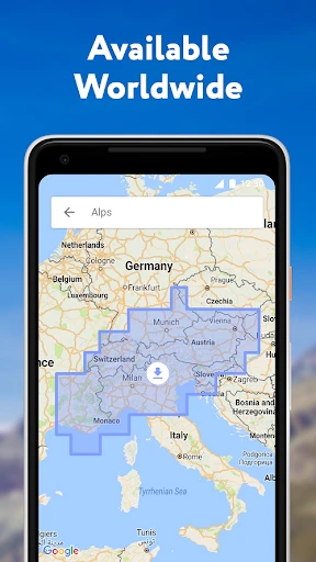
What truly sets PeakVisor apart is its user-friendly interface. The design is sleek and intuitive, ensuring that even the least tech-savvy users can navigate through its features with ease. The app also offers a rich database of over a million peaks worldwide, which is continuously updated to provide the most accurate information.
Additionally, PeakVisor offers virtual reality (VR) support, which is a fantastic way to preview hikes and explore landscapes from the comfort of your home. This feature adds a whole new dimension to planning your next adventure, making it easier to visualize the trails and peaks you’ll encounter.
Your Ultimate Hiking Companion
In conclusion, PeakVisor - 3D Maps & Peaks ID is more than just a hiking app; it's your ultimate companion for all mountain adventures. Whether you're a casual hiker or a dedicated mountaineer, this app enhances your experience by providing valuable insights and tools right at your fingertips.
So, the next time you’re gearing up for a hike, don’t forget to download PeakVisor. You’ll not only navigate mountains like a pro but also gain a deeper appreciation for the natural world around you. Happy hiking!
- Developer
- Routes Software SRL
- Version
- 2.8.71
- Installs
- 10,000+
- Android Version
- 8.0
- Content Rating
- Everyone
- Price
- $4.99
- Highly detailed 3D topographic maps.
- Offline maps available for remote areas.
- Accurate peak identification feature.
- User-friendly interface with easy navigation.
- Regular updates with new trails and peaks.
- Requires subscription for full features.
- Battery consumption is relatively high.
- Limited features on offline mode.
- Occasional lag in peak identification.
- Not suitable for non-mountainous regions.